Setting out is the construction side of Geomatics. It Mainly Involves the marking out of a design from
a drawing onto the ground or structure. The transfer from design to the real world can take the from
of measurements and alignment off existing detail or extracting Co-Ordinates from the design and
marking those positions on the ground. Totals Stations and Global Navigation Satellite System
(GNSS).
Preparation for Setting Out will Ordinarily be carried out off site without the pressure from site
operatives and management. These will optimise the use of AutoCAD and other specific survey
software (LSS).
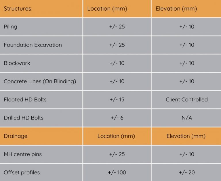
Table of expected relative accuracy:
On the first site visit original control stations will be located and checked the extent of the checks
will be relative to the project. We will consider that if the maximum error between PGMs does not
exceed 1 part in 20,000 for distances exceeding 200m and for shorter distances the maximum error
is not greater than +15mm then setting out can commence unless these amounts are greater than
the required accuracy (with reference to absolute and relative accuracy noted below) of the setting
out in which case adjustments to the control will be made. In the absence of original control
stations, a proving survey will be undertaken to survey exiting features that appear in the original
survey whilst suitable new permanent markers will be established. The resulting survey will be best
fitted to the client’s original survey and control station values will be deduced. We will aim to inform
you of control anomalies checks and proof surveys via a record of works sheet that will be presented
to the site supervisor on completion of the survey visit. Control may also be established with proof
surveys when tying into existing structures or other critical elements.
Absolute and Relative Accuracy
Relative accuracy refers to the precision of measurements
of one or more points to each other. For example, the relative distance between the two
GNSS points, while precise in absolute terms, could range from 0 cm to 4 cm, i.e., ±2 cm + ±2
cm. The distinction is particularly important when setting out using GNSS systems but
equally applies to other instruments. Absolute accuracy refers to the precision of individual.